

Mumbai Goa highway connectivity matters beyond a shorter road journey: it links freight gateways, tourist sites and communities across Konkan. The issue also illustrates how infrastructure shapes the economy.
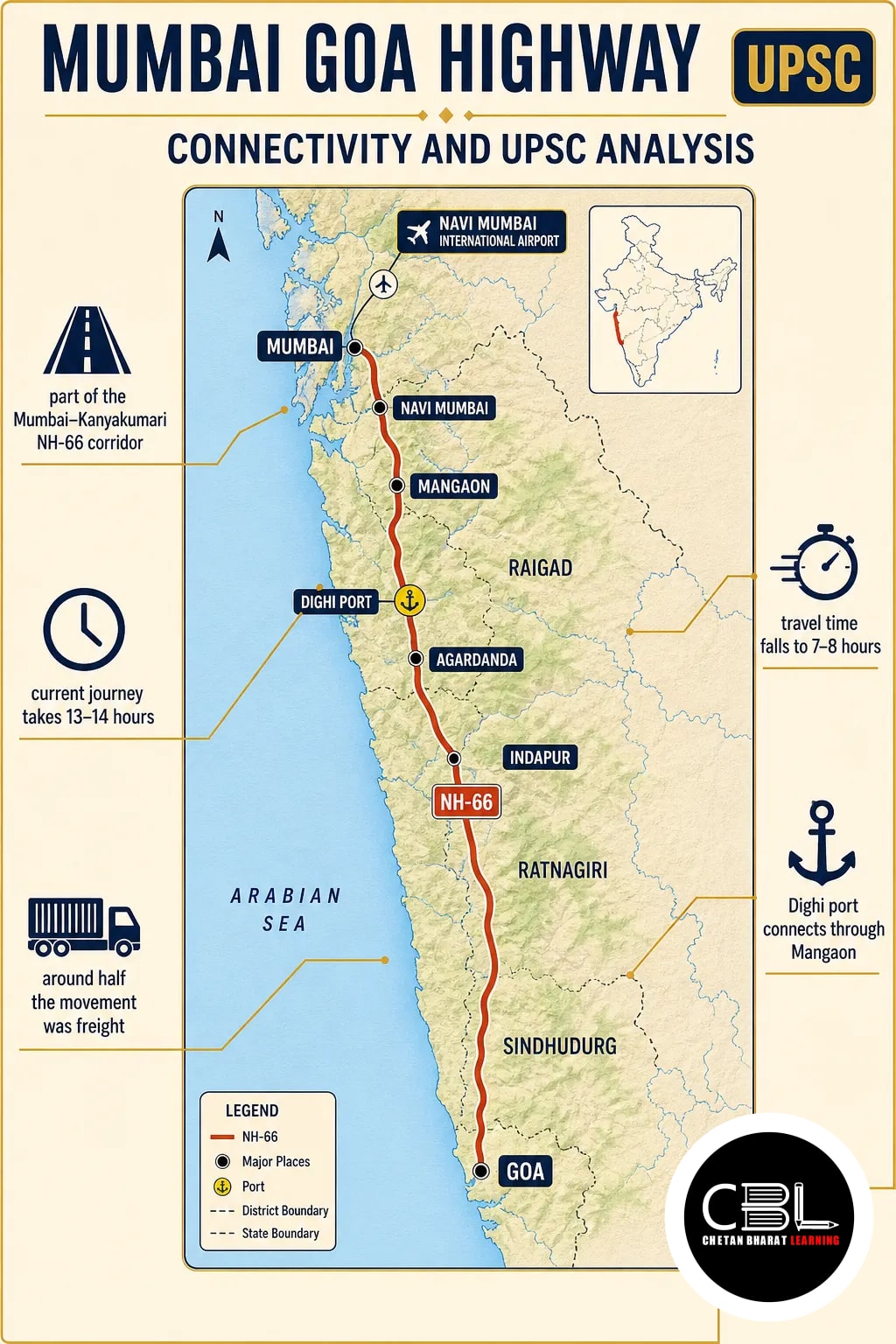
Quick answer: The Mumbai Goa highway forms part of the Mumbai–Kanyakumari National Highway 66 economic corridor. It connects Konkan with ports, tourist destinations and Navi Mumbai International Airport. On completion, travel between Mumbai and Goa is expected to fall from 13–14 hours to about 7–8 hours; key links nevertheless remain stuck.
What is the Mumbai Goa highway?
The highway section connects Mumbai and Goa as part of the Mumbai–Kanyakumari National Highway 66 (NH-66) economic corridor. It serves a large part of Konkan, including Raigad, Ratnagiri and Sindhudurg. Its significance therefore lies in connecting the region to markets and transport gateways, not just in moving vehicles between two cities.
An economic corridor brings together transport links and economic centres along a route. In this case, the road connects ports and an airport with destinations and settlements in the region. As a result, the quality of connecting roads matters alongside the main highway.
| Feature | Key fact |
|---|---|
| Larger route | Mumbai–Kanyakumari NH-66 economic corridor |
| Dighi port access | Via Mangaon |
| Agardanda access | Terminal and shipyard in Raigad, via Indapur |
| Airport link | Connects Konkan to Navi Mumbai International Airport |
Why is the corridor in the news?
The corridor is in focus because key connections to economic gateways remain stuck, even as its wider benefits are under discussion. The source notes the problem but does not identify the affected links or give their completion dates. Therefore, the reported delay should not be attributed to a particular port or airport access road without further evidence.
The projected journey-time reduction is a completion estimate, not a measure of current travel. Moreover, faster end-to-end movement depends on functioning access routes as well as the main road. A shorter highway journey alone cannot guarantee an equally short trip to every port or destination.
How does the highway support freight and ports?
The route carries freight between the Konkan region and important port facilities. It links Jawaharlal Nehru Port Terminal in Navi Mumbai, Dighi port via Mangaon, and the Agardanda terminal and shipyard via Indapur. These connections serve oil, chemicals, containers and bulk cargo.
A Ministry of Road Transport and Highways official estimated traffic at 30,000 passenger car units (PCU) per day near the starting stretch and 15,000 PCU per day near the Goa border. A PCU expresses traffic in comparable passenger-car equivalents rather than simply counting vehicles. The official also estimated that around half the movement was freight.
Thus, reliable port access can influence the time and predictability of cargo movement. For a comparison of another port-connectivity challenge, see the Vizhinjam port rail tunnel analysis. The modes differ, but both examples highlight the importance of links between a port and its inland network.
Why does the route matter to Konkan communities?
The route supports local travel, tourism and journeys between Konkan and the Mumbai region. During the annual Ganesh festival, it serves people returning to Konkan after migrating for work to Mumbai and Thane districts. Consequently, its value includes social and family connectivity as well as commercial traffic.
The Mumbai Goa highway also connects travellers to Harihareshwar temple, Diveagar Golden Ganesh temple, Murud-Janjira fort and Padmadurg fort. Better access can support visitor movement and local services. However, the eventual benefit depends on usable connections from the highway to individual sites.
In addition, the route links Konkan to Navi Mumbai International Airport. The airport was built to add capacity to Mumbai airport; road access can therefore help residents and businesses reach that aviation gateway.
What are the main planning challenges?
The central planning challenge is to deliver a connected corridor rather than treat each road segment in isolation.
- Last-mile access: Stuck links can limit the benefits of improvements on the main highway.
- Mixed traffic: Freight, local journeys and tourism share the route; therefore, planning must account for different travel needs.
- Peak demand: Festival travel adds a seasonal dimension to local movement, so planners should consider demand beyond an ordinary day.
- Outcome measurement: A projected seven-to-eight-hour journey does not by itself measure port access, local connectivity or reliability.
What should the way forward include?
Corridor planning should prioritise complete and usable connections between the highway and its major destinations. First, agencies can identify unfinished access links and publish their status. This would distinguish a main-carriageway milestone from an actual improvement in access to a port, airport or tourist site.
Second, planners should coordinate highway, port, airport and local-road requirements. For example, freight access needs must be considered alongside festival and local travel. In addition, monitoring should track journey reliability and destination access, not only the distance of road completed.
Finally, authorities should evaluate road safety and environmental safeguards as part of project delivery. Such checks are planning priorities; the supplied source does not establish a specific safety or environmental failure on this route. Overall, the goal is a corridor whose benefits reach both regional communities and economic gateways.
Source: The Indian Express, 16 November 2026
State PCS General Studies can test how highways connect production centres, transport gateways and local communities. For Punjab PCS and Haryana HCS, use this case to practise analysing last-mile connectivity and coordination across levels of government.
Prelims Practice Corner
Mains Practice Questions
Frequently Asked Questions
Which national highway includes the Mumbai–Goa section?
NH-66 includes the section. It is part of the Mumbai–Kanyakumari economic corridor.
How long will the Mumbai–Goa road journey take after completion?
Around seven to eight hours, according to the projection. In comparison, the current journey takes 13–14 hours.
Why is the highway important for freight?
It links the region to ports handling oil, chemicals, containers and bulk cargo. Moreover, an official estimated freight at around half of the section’s traffic movement.
Which port does the route connect through Mangaon?
Dighi port connects through Mangaon. In contrast, the Agardanda terminal and shipyard connect through Indapur.
Related Current Affairs
Preparing for UPSC, PCS or HCS?
Talk to a mentor at Chetan Bharat Learning, Chandigarh. Free guidance on choosing the right exam and building a study plan.
Chat on WhatsAppCall 97793 53345UPSC / IAS / PCS coaching in Chandigarh · Trusted by aspirants across Punjab & Haryana









Leave a Reply
You must be logged in to post a comment.