
The Vizhinjam port rail tunnel has sparked debate over rail connectivity, groundwater and land stability in Kerala. The proposal also raises questions relevant to environment and infrastructure planning.
Quick answer: The Vizhinjam port rail tunnel is a proposed 10.7-km connection between Balaramapuram and Vizhinjam in Thiruvananthapuram district. On 12 November 2026, The Hindu reported expert concerns about weak terrain, wells and buildings. Officials selected the route as the shortest connection to existing railway lines, while an expert proposed examining a surface alternative.
Where is the proposed rail tunnel?
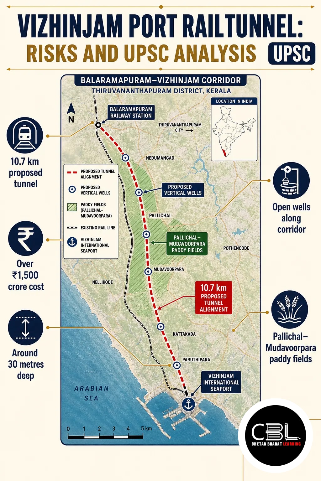
The proposed tunnel links Balaramapuram with Vizhinjam International Seaport in Kerala’s Thiruvananthapuram district. It is intended to connect the port to the railway network; officials selected it as the shortest route from existing lines.
| Feature | Details |
|---|---|
| Route | Balaramapuram–Vizhinjam |
| Length | 10.7 km |
| Cost | Over ₹1,500 crore |
| Approximate depth | 30 metres below the road surface |
| Purpose | Rail connectivity to Vizhinjam International Seaport |
The report describes it as potentially India’s third-longest railway tunnel and Kerala’s second major tunnel project. However, its route passes through densely populated areas, making the choice of alignment consequential for nearby households.
Why is the Vizhinjam port rail tunnel in the news?
Experts and residents have questioned the project’s environmental and social costs, particularly because an overland alternative exists. The Hindu reported their concerns on 12 November 2026.
V. Nandakumar, formerly associated with the National Centre for Earth Science Studies, questioned whether competent national institutions had conducted a comprehensive geological study. His concern covers soil variations, geological formations and east-to-west groundwater movement along the alignment. This is an expert assessment, not a finding that such studies definitely do not exist.
Senior government officials, meanwhile, said they chose the alignment because it was the shortest link to existing railway lines. The report also notes that a relatively lower-cost overland route is available through a paddy field.
What environmental and social risks need assessment?
The principal concerns are geological stability, groundwater disruption and possible damage to buildings and livelihoods. These are potential impacts identified in the report, not established outcomes.
Geology and ground stability
Nandakumar expects much of the route to pass through weak terrain. Beneath laterite, he expects decomposed lithomargic clay with hard rock in places; elsewhere, red soil may overlie clay and sand. Therefore, the actual subsurface profile needs detailed verification before judging tunnel design and safety.
He also warned that vibrations from heavy container trains could crack or damage buildings. Subsidence could add to structural risks; however, site-specific measurements are needed to establish their likelihood and scale.
Groundwater and households
Many residents along the corridor rely on open wells for drinking water. Nandakumar warned that the concrete tunnel could obstruct groundwater movement and eventually dry wells in an area already facing scarcity.
In addition, excavated rock and soil require safe disposal. The report also raises possible restrictions on development and property transactions above the tunnel and its buffer zone. Authorities should clarify whether such restrictions would apply and how affected owners would be treated.
The wider planning issue is how infrastructure can protect local water systems. For related context, see CBL’s coverage of the restoration of Tamil Nadu’s waterbodies.
How does the surface alternative compare?
The suggested alternative would follow lower-lying land, including the fringes of the Pallichal–Mudavoorpara paddy fields. Nandakumar said this land is about 10 metres lower than the proposed tunnel alignment.
According to him, a surface route could reduce risks to dense settlements, groundwater and structures. It could also lower construction and maintenance costs and make future track doubling easier. However, he called for its economic viability to be established before adoption.
A fair comparison must also examine land acquisition, livelihoods and impacts on paddy fields. Lower construction cost alone cannot establish the alternative’s overall advantage. Similarly, the Pallikaranai marshland construction issue illustrates why land-use choices need ecological scrutiny.
Why does the project matter for infrastructure planning?
The project illustrates the trade-off between a shorter freight connection and the risks associated with its location. Rail access can support port connectivity; nevertheless, a route’s full cost includes potential effects on water, buildings and land use.
Consequently, decision-makers need comparable evidence for both alignments rather than a choice based on distance alone. The issue also highlights how uncertainty can affect public confidence when residents depend on nearby wells and properties.
What should be the way forward?
A transparent comparison of the tunnel and surface route should guide the final alignment. The following measures address the specific concerns raised in the report:
- Independent assessment: Map subsurface geology and soil variability along the route, using competent technical institutions.
- Water and building baselines: Record well levels and building conditions before work; then monitor changes during construction and operation.
- Comparable alternatives: Assess costs, track expansion, land acquisition, paddy-field impacts and groundwater risks for both routes.
- Public safeguards: Explain proposed buffer-zone rules and provide a mechanism for residents to raise concerns and seek remedies.
- Excavated material: Prepare a disposal plan and monitor its implementation to reduce secondary environmental damage.
Overall, the selection should rest on verified evidence, economic viability and safeguards for affected communities. Neither route should be treated as risk-free without detailed assessment.
Source: The Hindu, 12 November 2026
State PCS General Studies may test how transport projects affect groundwater, land use and local communities. Candidates can also examine the role of state authorities in comparing alignments and addressing public concerns.
Prelims Practice Corner
Mains Practice Questions
Frequently Asked Questions
How long is the proposed Vizhinjam port rail tunnel?
It is proposed to be 10.7 km long. It would connect Balaramapuram with Vizhinjam in Thiruvananthapuram district.
Why are groundwater concerns being raised?
Mainly because the concrete tunnel could obstruct groundwater movement, according to expert V. Nandakumar. Many households along the corridor depend on open wells for drinking water.
Is there an alternative to the tunnel alignment?
Yes, an overland route through lower-lying areas has been suggested. However, Nandakumar said its economic viability should be established before it is adopted.
Why did officials select the proposed tunnel route?
They selected it as the shortest route from existing railway lines to the port. However, the report notes that a relatively lower-cost overland alignment is also available.
Related Current Affairs
Preparing for UPSC, PCS or HCS?
Talk to a mentor at Chetan Bharat Learning, Chandigarh. Free guidance on choosing the right exam and building a study plan.
Chat on WhatsAppCall 97793 53345UPSC / IAS / PCS coaching in Chandigarh · Trusted by aspirants across Punjab & Haryana








Leave a Reply
You must be logged in to post a comment.