
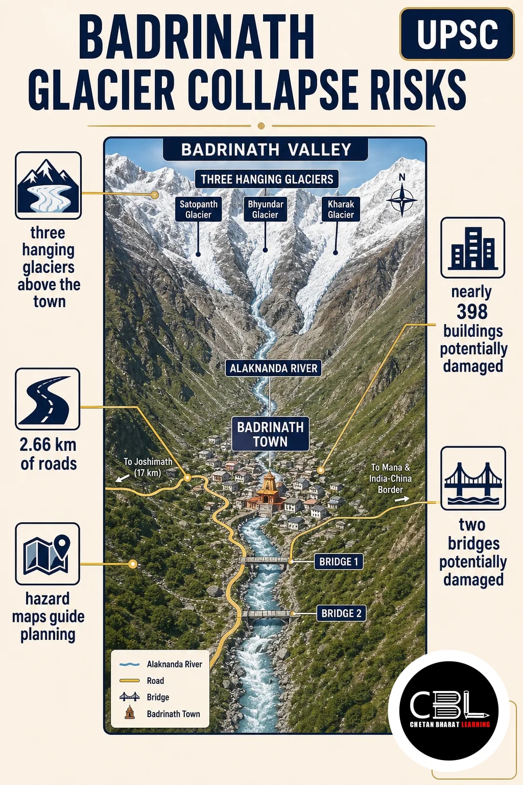

Badrinath glacier collapse risks have come into focus after a new modelling study assessed three hanging glaciers above the pilgrimage town. The findings connect Himalayan hazards with land-use planning and environment and disaster management.
Quick answer: Badrinath glacier collapse risks arise from three hanging glaciers above the Uttarakhand town. A study published on 28 October 2026 modelled a worst-case avalanche from the largest glacier. It estimated potential damage to nearly 398 buildings, 2.66 km of roads and two bridges. However, these are scenario estimates, not a prediction of an imminent collapse.
Where is Badrinath and what are hanging glaciers?
Badrinath lies on the Alaknanda River in Uttarakhand, below steep mountain slopes containing hanging glaciers. These ice bodies sit on slopes or end abruptly at bedrock cliffs, separated from the valley floor. If part of an ice mass detaches, it can produce an avalanche and rapidly release water and debris.
| Feature | Key fact |
|---|---|
| Badrinath elevation | Approximately 3,415 metres above mean sea level |
| River | Alaknanda, a major tributary of the Ganga |
| Glacier elevations | Between 4,700 and 5,465 metres above sea level |
| Pilgrimage exposure | Around 1.7 million temple visitors during the 2025 Char Dham yatra |
The study links a transition towards more temperate glacier conditions with reduced resistance at the ice base. Consequently, the likelihood of ice detachment and large-scale failure may increase. However, the study does not establish when a particular glacier might collapse.
Why are Badrinath glacier collapse risks in the news?
A peer-reviewed study in Landslides, published on 28 October 2026, assessed the damage potential of three glaciers above the town. Researchers from the Indian Institute of Science (IISc), the University of Cambridge and the Defence Research and Development Organisation (DRDO) conducted the study. DRDO funded the work.
First, the researchers used high-resolution satellite imagery and elevation models to identify hanging glaciers. They screened glaciers with mean surface slopes of at least 30 degrees and selected those near the town. Then, they estimated glacier volume, depth and vulnerable portions to simulate avalanches at the three sites.
The second site presented the greatest simulated damage potential. However, the researchers cautioned against treating the other two sites as minor threats. An earlier study identified 219 hanging glaciers; about 30 per cent were in the Alaknanda basin and had unstable ice mass.
What did the worst-case model find?
The largest assessed glacier could generate an avalanche capable of damaging buildings and key transport infrastructure under the modelled scenario. The estimates describe a possible worst case, not observed damage or a forecast of the event date.
| Indicator | Estimate for the second site |
|---|---|
| Glacier volume and slope | 5.32 million cubic metres; 34.57 degrees |
| Peak velocity and flow height | 78.5 metres per second; 73.5 metres |
| Buildings and roads | Nearly 398 buildings and 2.66 km of roads potentially damaged |
| Other infrastructure | Two bridges, a helipad and a parking area potentially damaged |
The model did not expect a direct hit on the Badrinath Dham shrine. Nevertheless, rocks and debris accumulated during an avalanche could affect it. The distinction matters: an area outside the modelled direct ice path may still face associated debris impacts.
Why does the risk matter for disaster management?
The study illustrates how a high-altitude hazard can threaten people and infrastructure concentrated downstream. Risk depends not only on a glacier failing but also on what lies within the potential flow path.
- Human exposure: Pilgrimage brings large numbers of visitors, so preparedness must account for a changing population.
- Critical access: Damage to roads and bridges could restrict movement; consequently, response planning must consider disrupted access.
- Multiple hazards: An ice avalanche can carry or release water and debris, so planners must assess more than the initial ice fall.
- Regional relevance: The three assessed sites and the earlier basin-wide inventory support a broader approach to Himalayan hazard mapping.
The assessment also has limits. Researchers relied on remotely sensed and model-derived release volumes and ice thickness rather than direct field measurements. Moreover, uncertain friction parameters affect simulated flow behaviour and runout, or the distance travelled by avalanche material. These limitations can change the magnitude of the estimated impacts.
What measures can reduce the risk?
Risk reduction requires hazard maps to guide construction, infrastructure planning and emergency preparedness. The researchers specifically recommend identifying impact and buffer zones using worst-case runout scenarios.
- Map the full footprint: Include potential ice, debris and flow runout; in addition, assess all three glacier sites.
- Regulate new construction: Restrict development in identified impact and buffer zones, as the researchers recommend.
- Improve estimates: Where feasible, supplement remote sensing with field measurements and test how friction assumptions change results.
- Plan for disruption: Identify safe evacuation routes and alternatives for access if roads or bridges become unusable.
- Review and communicate: Update maps as evidence improves; meanwhile, explain scenario uncertainty to residents and visitors.
Overall, the study offers a method for assessing other settlements near hanging glaciers. Its policy value lies in using uncertain but consequential scenarios to reduce exposure before a disaster, rather than treating a modelled figure as a precise forecast.
Source: The Indian Express, 29 October 2026
State PCS General Studies can test hanging glaciers, the Alaknanda and Himalayan disaster management. In addition, questions can ask how hazard maps inform district-level land use and emergency planning.
Prelims Practice Corner
Mains Practice Questions
Frequently Asked Questions
What is a hanging glacier?
A hanging glacier is an ice body on a mountain slope or ending at a bedrock cliff, detached from the valley floor. If ice detaches, it can cause an avalanche and release water and debris.
Would an avalanche directly hit the Badrinath shrine?
No, the study did not expect a direct hit on the shrine in its model. However, rocks and debris accumulated during an avalanche could affect it.
How many buildings could the worst-case avalanche damage?
Nearly 398 buildings could be damaged in the modelled worst case. However, the estimate depends on uncertain model parameters and is not an observed loss.
Does the study predict when a glacier will collapse?
No, the study assesses potential avalanche impacts rather than predicting a collapse date. Its scenarios can therefore inform preparedness without establishing that failure is imminent.
Related Current Affairs
Preparing for UPSC, PCS or HCS?
Talk to a mentor at Chetan Bharat Learning, Chandigarh. Free guidance on choosing the right exam and building a study plan.
Chat on WhatsAppCall 97793 53345UPSC / IAS / PCS coaching in Chandigarh · Trusted by aspirants across Punjab & Haryana
Leave a Reply
You must be logged in to post a comment.