Philippines Hit by Powerful 7.8-Magnitude Earthquake
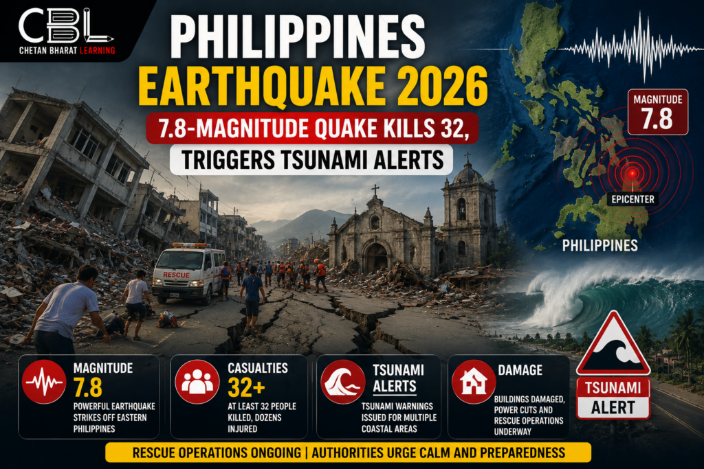
A devastating 7.8-magnitude earthquake struck the southern Philippines, leaving at least 32 people dead and more than a hundred injured. The powerful tremor was centered near the island of Mindanao and triggered widespread panic across several regions of the country. Rescue teams were immediately deployed as authorities assessed the scale of destruction caused by one of the strongest earthquakes to hit the Philippines in recent years.
The earthquake occurred in the early hours of the morning, catching many residents off guard. Buildings shook violently, roads developed cracks, and several structures collapsed. The impact was felt far beyond the epicenter, with tremors reported in neighboring parts of Indonesia and Malaysia.
The disaster once again highlighted the vulnerability of countries located within the Pacific Ring of Fire, one of the most seismically active regions in the world.
Why Did the Earthquake Occur?
The Philippines lies along the Pacific Ring of Fire, a vast zone characterized by frequent earthquakes, volcanic eruptions, and tectonic activity. The region is formed by the interaction of several tectonic plates, including the Philippine Sea Plate and the Eurasian Plate.
When these plates move, collide, or slide against each other, enormous amounts of energy are released in the form of seismic waves. This energy travels through the Earth’s crust and causes earthquakes.
Because of its geographical location, the Philippines experiences thousands of earthquakes every year, although only a few cause significant damage and casualties.
The recent 7.8-magnitude earthquake serves as a reminder of the geological risks faced by countries situated in tectonically active zones.
Impact on Mindanao and Surrounding Areas
The southern island of Mindanao suffered the most severe damage from the earthquake. Several residential buildings, commercial establishments, and public infrastructure were affected.
Authorities reported that many casualties occurred due to collapsing structures, falling debris, and landslides triggered by the powerful tremors. Search and rescue teams worked continuously to locate survivors trapped under damaged buildings.
In General Santos City and nearby areas, residents described the earthquake as one of the strongest they had ever experienced. Many families were forced to leave their homes and seek shelter in open spaces due to fears of aftershocks.
The disaster disrupted transportation networks, communication systems, and essential services in several regions.
Tsunami Warnings Issued Across the Region
Following the earthquake, tsunami warnings were issued for parts of the Philippines, northern Indonesia, and regions near Borneo. Emergency authorities closely monitored sea-level changes to determine whether dangerous waves would develop.
Tsunami warnings are common after major undersea earthquakes because sudden movements of the ocean floor can displace large volumes of water, generating powerful waves that travel across oceans.
Although authorities later cancelled the warnings after monitoring conditions for several hours, the precautionary measures played an important role in ensuring public safety.
The event demonstrated the importance of early warning systems in reducing disaster-related casualties.
Government Response and Rescue Operations
The Philippine government launched an immediate emergency response following the earthquake. Disaster management agencies, military personnel, and local authorities coordinated rescue efforts across affected regions.
Relief supplies, medical assistance, and temporary shelters were arranged for displaced families. Emergency teams focused on clearing debris, restoring transportation routes, and ensuring access to essential services.
Government officials emphasized that relief operations would continue until all affected communities received necessary support. The response also included damage assessments to determine the extent of losses and reconstruction requirements.
Such coordinated disaster management efforts are critical in minimizing the humanitarian impact of large-scale natural disasters.
Economic and Social Consequences
Beyond the immediate loss of life and property, earthquakes often create significant economic challenges. Infrastructure damage can disrupt businesses, transportation, tourism, and local economic activities.
For developing countries, rebuilding damaged infrastructure requires substantial financial resources. Schools, hospitals, roads, and public utilities may take months or even years to fully recover.
The social impact is equally significant. Families may lose homes, livelihoods, and access to basic services. Psychological stress and trauma often persist long after the physical damage has been repaired.
The Philippines now faces the challenge of balancing immediate relief measures with long-term recovery and reconstruction efforts.
Importance of Disaster Preparedness
The earthquake highlights the importance of disaster preparedness and resilience-building strategies. Countries located in seismically active regions must invest in stronger infrastructure, public awareness campaigns, and efficient emergency response systems.
Earthquake-resistant buildings can significantly reduce casualties during major seismic events. Public education programs help citizens understand evacuation procedures and emergency safety measures.
Technological advancements such as early warning systems, real-time monitoring networks, and improved communication infrastructure also play an important role in disaster risk reduction.
The recent disaster demonstrates that preparedness remains one of the most effective tools for minimizing losses during natural calamities.
Pacific Ring of Fire: A Global Seismic Hotspot
The Pacific Ring of Fire is a horseshoe-shaped belt surrounding the Pacific Ocean where nearly 75% of the world’s volcanoes and about 90% of earthquakes occur.
Countries such as Japan, Indonesia, the Philippines, New Zealand, Chile, and parts of the United States are located within this highly active zone.
Frequent tectonic activity makes these countries particularly vulnerable to earthquakes, volcanic eruptions, and tsunamis. Governments in these regions continuously invest in monitoring systems and disaster preparedness measures to reduce risks.
Understanding the Pacific Ring of Fire is essential for analyzing global seismic events and their broader implications.
Relevance for UPSC Aspirants
The Philippines earthquake is important from a UPSC perspective because it covers topics related to Geography, Disaster Management, Environment, and International Current Affairs.
Aspirants should understand:
- Causes of earthquakes
- Plate tectonics and seismic activity
- Pacific Ring of Fire
- Tsunami formation
- Disaster management strategies
- International cooperation during natural disasters
Questions related to earthquakes, tectonic plates, and disaster preparedness frequently appear in both UPSC Prelims and Mains examinations.
FAQs
What was the magnitude of the Philippines earthquake?
The earthquake measured 7.8 on the Richter Scale, making it one of the strongest earthquakes recorded in the region recently.
Which area was most affected?
Mindanao in southern Philippines experienced the greatest impact, with casualties, injuries, and infrastructure damage.
Why was a tsunami warning issued?
The powerful earthquake raised concerns about possible displacement of seawater, which can generate tsunami waves.
What is the Pacific Ring of Fire?
It is a highly active seismic and volcanic zone surrounding the Pacific Ocean where most of the world’s earthquakes occur.
Why is this topic important for UPSC?
It relates to Geography, Disaster Management, Plate Tectonics, Natural Hazards, and Current Affairs.
Conclusion
The 7.8-magnitude earthquake in the Philippines serves as a stark reminder of the destructive power of natural disasters and the challenges faced by countries situated in tectonically active regions. While rescue operations and relief efforts continue, the tragedy underscores the importance of preparedness, resilient infrastructure, and effective disaster management systems.
As climate and geological risks increasingly affect populations worldwide, governments must strengthen disaster response capabilities and invest in long-term resilience measures. The lessons from the Philippines earthquake highlight the need for continuous monitoring, public awareness, and international cooperation in reducing the impact of future natural disasters.
Leave a Reply
You must be logged in to post a comment.