
UPSC Syllabus Mapping
- GS Paper: GS-I, GS-II and GS-III
- Subject: World Geography, Mapping, International Relations, Maritime Security and Energy Security
What is Bab el-Mandeb Strait?
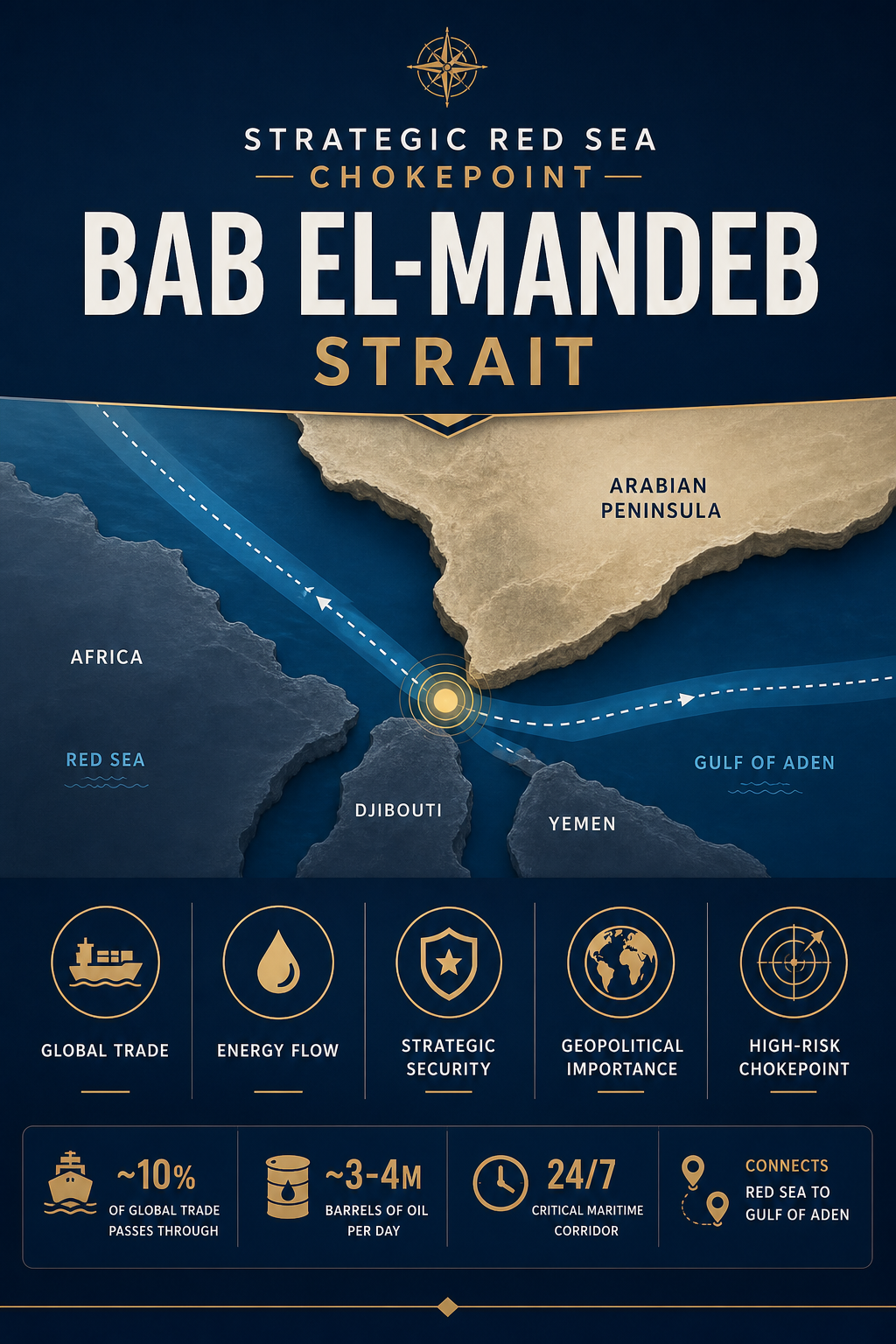
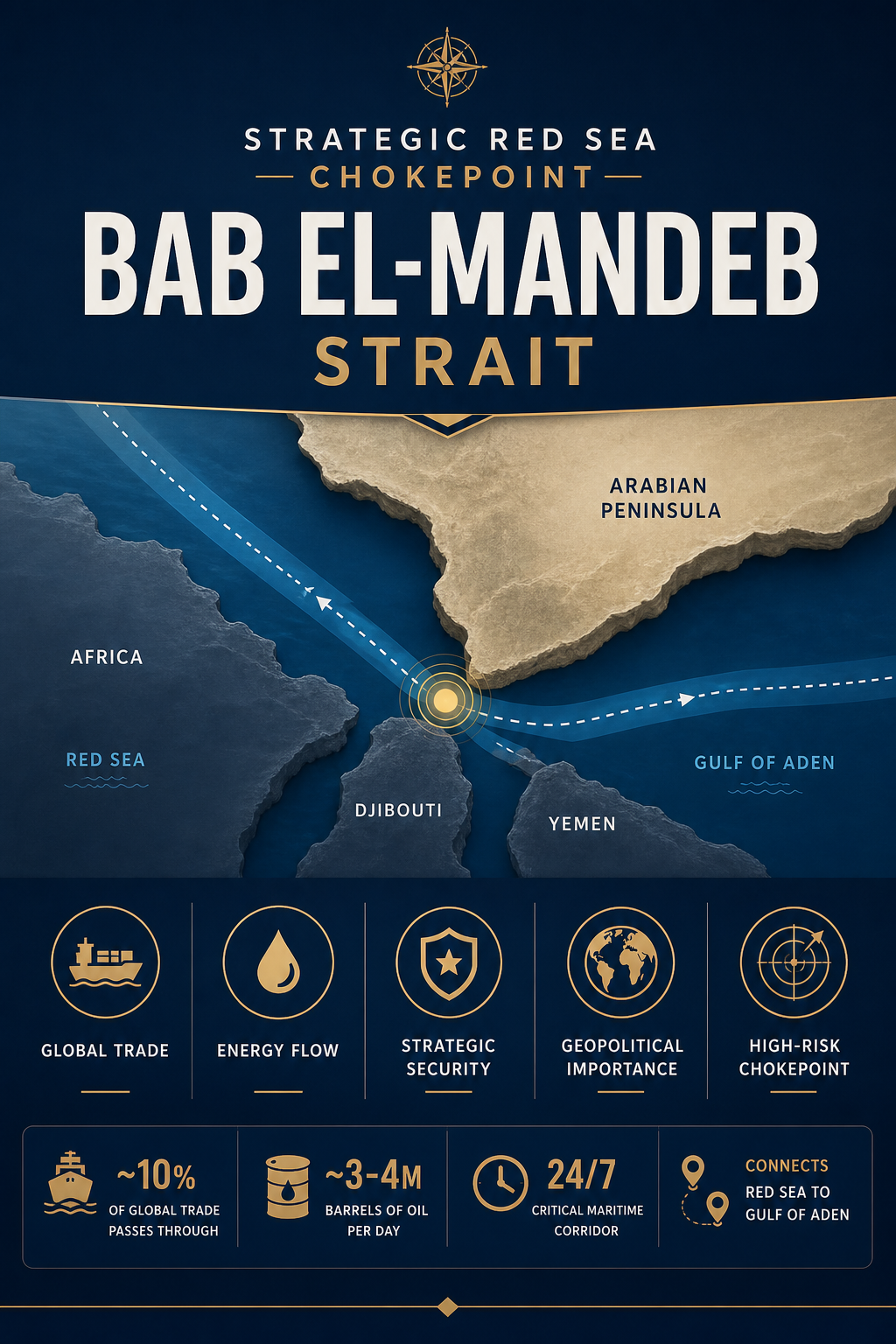
The passage is a narrow maritime strait situated between the Arabian Peninsula and the Horn of Africa. Its name is commonly translated from Arabic as the Gate of Tears. Geographically, it connects the Red Sea to the Gulf of Aden, from where ships can proceed into the Arabian Sea and the wider Indian Ocean. Yemen lies on its northeastern side, while Djibouti and Eritrea are located on the African side of the surrounding maritime region.
Its importance becomes clearer when viewed as part of a larger maritime corridor. Vessels travelling between the Indian Ocean and Mediterranean Sea can pass through the Gulf of Aden, this strait, the Red Sea and the Suez Canal. This creates one of the principal maritime connections between Asia and Europe. Consequently, the geography of a relatively narrow passage can influence global trade routes extending thousands of kilometres beyond its immediate neighbourhood.
Why is Bab el-Mandeb Strait in News?
The strait entered current affairs after Yemen’s Houthi rebels announced a targeted naval embargo involving Saudi Arabia and threatened oil-tanker movements through the Red Sea corridor. The development highlights how conflict around a maritime chokepoint can produce economic consequences beyond the countries directly involved. Even the risk of attacks or disruption can influence shipping decisions because carriers must consider crew safety, insurance premiums and the possibility of delays.
The waterway is strategically connected with international energy and merchandise trade passing through the Red Sea-Suez route. When security conditions deteriorate, shipping companies may reroute vessels around Africa’s Cape of Good Hope. Such diversion significantly increases sailing distance and transit time and can raise fuel and freight costs.
Key Geographical Features of the Strait
At its narrow section, the passage is roughly 30 kilometres wide. Perim, also known as Mayun Island, lies within the strait and divides it into two channels. The western channel is broader and deeper and is consequently more important for large-scale international navigation. The eastern channel between Perim Island and Yemen is considerably narrower and shallower.
- Water bodies: It links the Red Sea in the northwest with the Gulf of Aden towards the southeast.
- Asian shore: Yemen occupies the Arabian Peninsula side of the passage.
- African shore: Djibouti and nearby Eritrea form the Horn of Africa side of the surrounding maritime geography.
- Perim Island: The volcanic island divides the passage into eastern and western navigation channels.
- Western channel: The wider and deeper passage accommodates major commercial shipping.
- Regional islands: The volcanic Seven Brothers, or Sawabi Islands, are located near Djibouti.
The strait also forms an important zone of water exchange between the Red Sea and Gulf of Aden. Surface circulation varies seasonally under the influence of regional winds and monsoon dynamics. For Prelims mapping, aspirants should remember the sequence Mediterranean Sea → Suez Canal → Red Sea → Bab el-Mandeb → Gulf of Aden → Arabian Sea.
Challenges Related to Bab el-Mandeb Strait
The primary strategic challenge arises from chokepoint concentration. A large volume of international shipping passes through a geographically restricted corridor, so conflict, attacks, accidents or other disruptions can create effects disproportionate to the strait’s physical size. Energy cargoes are particularly sensitive because disruptions can affect transportation costs and market expectations even when physical supplies remain available elsewhere.
Security conditions around the Red Sea are complicated by regional conflicts, armed non-state actors and geopolitical competition. Commercial vessels are not designed to operate as military platforms, making prolonged insecurity costly for shipping companies. Naval deployments can help protect maritime traffic but also increase the concentration of military assets in an already contested region.
Diversion around the Cape of Good Hope provides an alternative route, but it increases distance, voyage duration, fuel consumption and shipping costs. Longer journeys also tie up vessels for additional time, potentially reducing effective shipping capacity.
Way Forward for Red Sea Maritime Security
Maintaining safe navigation requires cooperation among coastal states, major trading economies and maritime organisations. Information sharing, maritime-domain awareness and protection of commercial shipping can reduce immediate risks. At the same time, naval security measures cannot substitute for diplomatic resolution of conflicts that generate repeated threats to shipping.
Trading countries should also strengthen supply-chain resilience. Companies can diversify routes and logistics arrangements, while governments can monitor vulnerabilities affecting strategic commodities. For India, greater port efficiency, shipping capacity, energy-source diversification and maritime-domain awareness can reduce exposure to external disruptions.
International maritime law provides the broader framework within which navigation rights and coastal-state interests are considered. The International Maritime Organization works on the safety and security of international shipping. The central lesson is that maritime chokepoints convert physical geography into strategic power: disruptions in a narrow waterway can transmit economic and security consequences across global supply chains.
Prelims Practice Corner
-
Q1. The Bab el-Mandeb connects which two water bodies?
(a) Mediterranean Sea and Red Sea
(b) Red Sea and Gulf of Aden
(c) Persian Gulf and Gulf of Oman
(d) Arabian Sea and Persian GulfAnswer: (b) It connects the Red Sea with the Gulf of Aden.
-
Q2. Which of the following countries are associated with the immediate geography of the strait?
1. Yemen
2. Djibouti
3. Eritrea(a) 1 only
(b) 1 and 2 only
(c) 2 and 3 only
(d) 1, 2 and 3Answer: (d) Yemen lies on the Arabian side, while Djibouti and Eritrea are on the African side of the surrounding maritime region.
-
Q3. Perim or Mayun Island is located in:
(a) Strait of Hormuz
(b) Bab el-Mandeb
(c) Strait of Malacca
(d) BosporusAnswer: (b) Perim Island lies within the strait and divides it into two channels.
-
Q4. Consider the following sequence from north to south: 1. Suez Canal 2. Red Sea 3. Bab el-Mandeb 4. Gulf of Aden. Which option gives the correct order?
(a) 1-2-3-4
(b) 2-1-4-3
(c) 1-3-2-4
(d) 3-2-1-4Answer: (a) Ships moving south from the Mediterranean pass through the Suez Canal, Red Sea, Bab el-Mandeb and then Gulf of Aden.
-
Q5. A prolonged disruption of the Red Sea-Suez route would most directly encourage shipping diversion around:
(a) Cape Horn
(b) Cape of Good Hope
(c) Bering Strait
(d) Strait of GibraltarAnswer: (b) Ships can divert around the Cape of Good Hope at the southern end of Africa.
Mains Practice Questions
-
Q1. Explain how maritime chokepoints influence global trade and energy security. Illustrate with examples from the western Indian Ocean region. (10 marks)
Outline: Define maritime chokepoint; explain geographic concentration of shipping; discuss the Red Sea-Suez corridor, energy flows and rerouting costs; mention Hormuz as a comparative example; conclude with supply-chain resilience.
-
Q2. Instability around the Red Sea has consequences extending far beyond West Asia. Examine its implications for India’s economic and maritime interests. (15 marks)
Outline: Map the Suez-Red Sea-Gulf of Aden route; discuss trade with Europe, shipping costs, energy security and insurance; examine regional security threats; suggest maritime-domain awareness, diplomacy, route resilience and stronger shipping capabilities.
FAQs on the Red Sea Chokepoint
- Where is the Bab el-Mandeb Strait located?
- It lies between Yemen on the Arabian Peninsula and the Horn of Africa, connecting the Red Sea with the Gulf of Aden and onward maritime routes into the Indian Ocean.
- Why is the waterway strategically important?
- It forms the southern gateway to the Red Sea-Suez Canal corridor, making it an important route for commercial shipping and energy cargoes travelling between Asia, Europe and the Mediterranean region.
- Why is the strait important for UPSC?
- It is relevant for world mapping, physical and economic geography, maritime security, energy security and international relations, particularly questions involving the Red Sea, Gulf of Aden, Suez Canal and Indian Ocean.
Related Current Affairs
Preparing for UPSC, PCS or HCS?
Talk to a mentor at Chetan Bharat Learning, Chandigarh. Free guidance on choosing the right exam and building a study plan.
Chat on WhatsAppCall 97793 53345UPSC / IAS / PCS coaching in Chandigarh · Trusted by aspirants across Punjab & Haryana
Leave a Reply
You must be logged in to post a comment.