

Important For
| Prelims | World Geography, International Relations and Map-Based Questions |
|---|---|
| Mains | GS Paper II – Bilateral Relations and GS Paper I – World Geography |
Punjab & Haryana PCS Angle
For Punjab PCS and Haryana HCS, Ethiopia is relevant to world geography, international relations and map-based General Studies questions. Candidates should locate its six neighbouring countries, the Ethiopian Highlands, Great Rift Valley, Blue Nile and Addis Ababa. The India–Ethiopia defence meeting also provides an example of India’s expanding diplomatic and defence engagement with African countries.
Introduction
Ethiopia Geography has gained examination relevance following the second Joint Defence Cooperation meeting between India and Ethiopia in Addis Ababa on 28 September 2026. The meeting focused on expanding bilateral cooperation in military training, joint exercises, defence industries and peacekeeping. Ethiopia’s location in the Horn of Africa, its major river systems and its proximity to important international maritime routes make it strategically significant. Explore related regional developments through the Red Sea geography and strategic importance article.
Quick Facts
| Capital | Addis Ababa |
|---|---|
| Region | Horn of Africa |
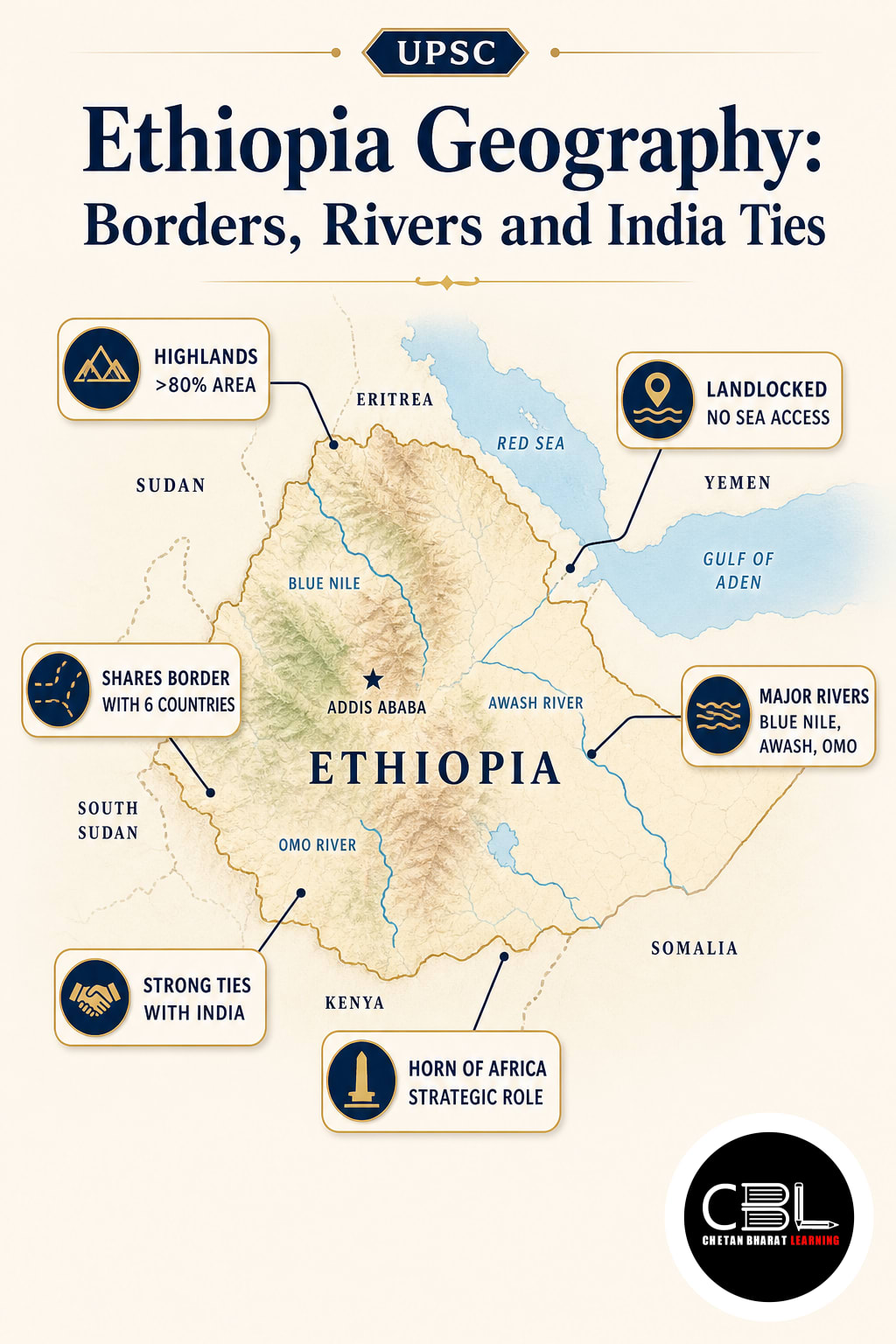
| Borders | Six Countries (Eritrea, Djibouti, Somalia, Kenya, South Sudan, Sudan) |
| Highest Peak | Ras Dejen (approx. 4,550 m) |
Location and Key Features
Ethiopia is a landlocked country in eastern Africa, situated in the strategically important Horn of Africa. Its capital, Addis Ababa, also hosts the headquarters of the African Union.
Ethiopia became landlocked following Eritrea’s independence in 1993, losing its former direct coastline along the Red Sea. It shares land boundaries with six countries:
- North: Eritrea
- Northeast: Djibouti
- East: Somalia
- South: Kenya
- West: South Sudan and Sudan
The country’s terrain includes the Ethiopian Highlands, Western and Eastern Lowlands, mountain ranges and the East African Rift system. The Great Rift Valley divides the highlands into major geographical regions.
Ethiopia’s highest peak is Ras Dejen (Ras Dashen), approximately 4,550 metres above sea level. The Danakil Depression contains some of the country’s lowest and hottest terrain.
Major rivers include the Blue Nile, Awash and Shebelle. The Blue Nile originates from Lake Tana in the Ethiopian Highlands and later joins the White Nile at Khartoum in Sudan.
Climate varies considerably with elevation. Highlands generally experience cooler conditions, while the eastern and northeastern lowlands include hot, arid and semi-arid areas. Seasonal rainfall strongly influences agriculture and water availability.
Why in News?
India and Ethiopia held their second Joint Defence Cooperation (JDC) meeting in Addis Ababa on 28 September 2026. The meeting strengthened the institutional framework for bilateral military engagement.
The discussions covered military training, joint exercises, medical cooperation, peacekeeping and defence industries. Both countries agreed to explore personnel exchanges, defence production partnerships and greater interaction between their defence institutions.
India’s delegation was led by Sanjay Kumar, Joint Secretary in the Ministry of Defence, while Ethiopia was represented by Major General Teshome Gemechu, Director General for Defence Foreign Relations and Military Cooperation.
The meeting followed the Defence Cooperation Memorandum of Understanding signed in February 2025 and the first JDC meeting held in New Delhi in October 2025.
India and Ethiopia have maintained defence cooperation since 1958. Their bilateral relationship was elevated to a Strategic Partnership in December 2025 during the Indian Prime Minister’s visit to Ethiopia.
The Ministry of Defence press release dated 28 September 2026 confirms the meeting’s agenda and bilateral outcomes.
Ecological or Strategic Significance
Ethiopia’s geographical position gives it substantial importance in African regional politics, transboundary water management and international connectivity. Although landlocked, the country lies close to the Red Sea and Gulf of Aden trade routes.
- Horn of Africa: Central position in a region connecting Africa with the Red Sea, Arabian Peninsula and Indian Ocean trade networks.
- African Union headquarters: Addis Ababa is a major centre for continental diplomacy because it hosts the African Union headquarters and numerous international institutions.
- Blue Nile Basin: Ethiopia’s highlands contribute significantly to the Nile river system, making transboundary water cooperation important for Ethiopia, Sudan and Egypt.
- Hydropower potential: The country’s elevated terrain and river systems support electricity generation, including the Grand Ethiopian Renaissance Dam on the Blue Nile.
- Defence cooperation: India’s engagement with Ethiopia supports military training, professional exchanges, peacekeeping collaboration and exploration of defence industrial partnerships.
- Geological importance: The East African Rift system provides an important example of divergent tectonic processes, volcanic activity and continental rifting.
The African Union’s official website confirms the location of its headquarters in Addis Ababa.
Threats
- Drought and water scarcity: Rainfall variability affects agricultural production, livestock livelihoods and access to water, especially in dry lowland areas.
- Land degradation: Soil erosion, deforestation and unsustainable land-use practices threaten agricultural productivity and environmental stability.
- Geological hazards: The East African Rift system exposes parts of Ethiopia to earthquakes and volcanic activity.
- Transboundary water disputes: Management of the Blue Nile and the Grand Ethiopian Renaissance Dam raises diplomatic questions involving downstream Sudan and Egypt.
- Landlocked constraints: Dependence on neighbouring countries for access to seaports creates logistical vulnerabilities and increases the importance of regional connectivity.
- Regional instability: Political tensions, armed conflicts and humanitarian emergencies in the wider Horn of Africa can affect economic development and cross-border cooperation.
Conservation and Policy Measures
Ethiopia’s long-term development requires coordinated efforts in environmental protection, regional diplomacy and infrastructure investment. Sustainable land management, soil conservation and climate-resilient agriculture can reduce pressure on natural resources.
The World Bank has highlighted soil degradation as a major threat to agricultural livelihoods in Ethiopia. Restoration programmes involving farmers, watershed management and improved agricultural practices can support resilience and food security.
Transboundary river governance requires cooperation with neighbouring countries. Information sharing and negotiated arrangements concerning the Blue Nile can help balance electricity generation with downstream water security.
The United Nations discussion on the Grand Ethiopian Renaissance Dam explains the importance of cooperation among Ethiopia, Sudan and Egypt.
For India, continued cooperation through diplomatic engagement, military training and development partnerships can strengthen ties with Ethiopia. Building stable institutions and supporting peaceful regional cooperation can also improve the strategic environment of the Horn of Africa.
Understanding Ethiopia Geography is important for connecting physical geography with contemporary international relations. Its rivers, highlands, Rift Valley and regional location demonstrate how natural features influence economic and strategic decisions. Explore comparable developments through the current affairs archive.
Prelims Practice Corner
Q1. Which of the following countries share a land boundary with Ethiopia?
1. Eritrea 2. Djibouti 3. Kenya 4. Uganda
Options: (a) 1 and 4 only (b) 2, 3 and 4 only (c) 1, 2 and 3 only (d) 1, 2, 3 and 4
Answer: (c) Eritrea, Djibouti and Kenya border Ethiopia. Uganda does not share a land boundary with Ethiopia.
Q2. Ethiopia became a landlocked country following the independence of which country in 1993?
Options: (a) Eritrea (b) Djibouti (c) Somalia (d) South Sudan
Answer: (a) Eritrea gained independence from Ethiopia in 1993, leaving Ethiopia without direct access to the Red Sea.
Q3. Consider the following statements about Ethiopia:
1. The Blue Nile originates from Lake Tana. 2. The Great Rift Valley passes through Ethiopia. 3. Mount Kilimanjaro is Ethiopia’s highest peak.
Which statements are correct? (a) 1 and 3 only (b) 2 and 3 only (c) 1, 2 and 3 (d) 1 and 2 only
Answer: (d) Statements 1 and 2 are correct. Ras Dejen is Ethiopia’s highest peak, while Mount Kilimanjaro is located in Tanzania.
Q4. The second Joint Defence Cooperation meeting between India and Ethiopia in September 2026 was held in:
Options: (a) Nairobi (b) Addis Ababa (c) Djibouti City (d) Khartoum
Answer: (b) The meeting took place in Addis Ababa on 28 September 2026 and focused on expanding bilateral defence cooperation.
Q5. Consider the following statements:
1. Addis Ababa hosts the African Union headquarters. 2. Ethiopia has a coastline along the Gulf of Aden. 3. The Grand Ethiopian Renaissance Dam is located on the Blue Nile.
Which statements are correct? (a) 1 and 2 only (b) 2 and 3 only (c) 1 and 3 only (d) 1, 2 and 3
Answer: (c) Statements 1 and 3 are correct. Ethiopia is landlocked and has no coastline along the Gulf of Aden or Red Sea.
Mains Practice Questions
Q1. Examine the strategic importance of Ethiopia in the Horn of Africa and discuss the significance of India’s expanding defence cooperation with the country. (15 marks)
Answer Structure:
- Intro: Introduce Ethiopia’s location in the Horn of Africa and its importance in regional diplomacy.
- Body: Discuss Ethiopia’s geographical position, African Union headquarters, proximity to maritime routes, defence cooperation, peacekeeping, military training and regional security challenges.
- Conclusion: Highlight the importance of sustained diplomatic engagement, regional stability and mutually beneficial defence partnerships.
Q2. Explain how Ethiopia’s physical geography influences its economic development, water resources and regional relations. (10 marks)
Answer Structure:
- Intro: Describe Ethiopia as a landlocked country characterised by highlands, lowlands and the East African Rift system.
- Body: Examine the Blue Nile Basin, hydropower potential, varied climate, agricultural dependence, drought, geological hazards and cross-border water management.
- Conclusion: Recommend sustainable resource management and regional cooperation to balance development with environmental security.
Frequently Asked Questions
Where is Ethiopia located and which countries border it?
Ethiopia is a landlocked country in the Horn of Africa. It borders Eritrea, Djibouti, Somalia, Kenya, South Sudan and Sudan. Its capital is Addis Ababa.
Why is Ethiopia important for India?
Ethiopia is an important Indian partner in the Horn of Africa. The two countries cooperate in defence training, peacekeeping, diplomatic engagement and other bilateral activities, and their relationship was elevated to a Strategic Partnership in December 2025.
What are the major geographical features of Ethiopia?
Major features include the Ethiopian Highlands, Great Rift Valley, Danakil Depression, Lake Tana and the Blue Nile, Awash and Shebelle rivers. Ras Dejen is its highest peak, and the country has no coastline following Eritrea’s independence in 1993.
Related Current Affairs
Preparing for UPSC, PCS or HCS?
Talk to a mentor at Chetan Bharat Learning, Chandigarh. Free guidance on choosing the right exam and building a study plan.
Chat on WhatsAppCall 97793 53345UPSC / IAS / PCS coaching in Chandigarh · Trusted by aspirants across Punjab & Haryana
Leave a Reply
You must be logged in to post a comment.