

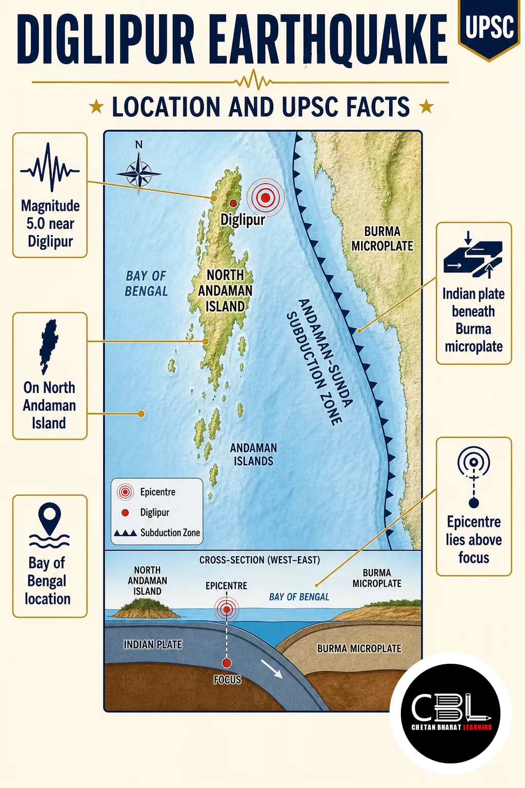
The Diglipur earthquake brought attention to seismic activity in the Andaman Islands. For more developments, explore CBL’s current affairs coverage.
Quick answer: A magnitude 5.0 Diglipur earthquake struck near Diglipur in the Andaman Islands, according to news coverage dated 29 October 2026. The islands lie near a tectonically active plate boundary. However, the supplied report does not specify the earthquake’s depth, exact coordinates, damage or any tsunami warning.
Where is Diglipur?
Diglipur lies on North Andaman Island in the Andaman and Nicobar Islands. The island group sits in the Bay of Bengal; together, the Andaman and Nicobar Islands form a Union Territory of India.
| Feature | Key fact |
|---|---|
| Diglipur | On North Andaman Island |
| Island group | Andaman Islands |
| Water body | Bay of Bengal |
| Administrative status | Part of the Andaman and Nicobar Islands Union Territory |
Why is the Diglipur earthquake in the news?
News coverage dated 29 October 2026 described a magnitude 5.0 earthquake near Diglipur. However, the supplied source does not give its exact coordinates or depth. It also does not provide casualty figures, damage details or a tsunami warning.
Therefore, students should distinguish the reported magnitude from the local effects, which the supplied source does not establish. A magnitude figure alone cannot specify the shaking at every location.
Why are the Andaman Islands earthquake-prone?
The islands lie close to a tectonically active convergent plate boundary. In this region, the Indian plate moves beneath the Burma microplate along the Andaman-Sunda subduction system.
As a result, stress can accumulate where plates interact and release as earthquakes. However, this regional setting does not establish the precise fault or mechanism of the Diglipur earthquake.
The island chain is also important for understanding the geography of the eastern Indian Ocean. For prelims, locate North Andaman and distinguish the Andaman Islands from the Nicobar Islands farther south.
What earthquake terms should aspirants know?
Magnitude, intensity, focus and epicentre describe different aspects of an earthquake.
- Magnitude: It measures the earthquake’s size using seismic recordings; therefore, it is not a direct measure of damage.
- Intensity: It describes shaking and its effects at a particular place; consequently, it can vary across locations.
- Focus: Also called the hypocentre, it is the point within Earth where rupture begins.
- Epicentre: It is the point on Earth’s surface directly above the focus; however, the supplied report gives no exact coordinates for this event.
What are the risks and response priorities?
Earthquake impacts depend on shaking, exposure and the vulnerability of structures. For example, building quality and ground conditions can influence damage even at places affected by the same earthquake.
- Coastal risk: Some undersea earthquakes can generate tsunamis; however, magnitude alone does not confirm one.
- Preparedness: Earthquake-resistant construction and public drills can reduce vulnerability.
- Official information: People should follow verified local instructions rather than infer warnings from magnitude alone.
The supplied source does not establish whether this earthquake caused damage or triggered a tsunami. Therefore, those outcomes should not be assumed.
Source: Indian Express, 29 October 2026
Asked in UPSC: Previous Year Questions
- UPSC CSE Mains 2021 (GS Paper III): Discuss India’s vulnerability to earthquake hazards, with examples and salient features of major earthquake disasters in different parts of India during the last three decades.
UPSC connects earthquake hazards with regional vulnerability, so revise both physical geography and disaster management.
Punjab PCS and Haryana HCS General Studies can test earthquake terminology and plate boundaries. In addition, revise disaster preparedness as a state governance responsibility.
Prelims Practice Corner
Mains Practice Questions
Frequently Asked Questions
What was the magnitude of the earthquake near Diglipur?
It was magnitude 5.0. The news coverage located it near Diglipur in the Andaman Islands.
Where is Diglipur located?
Diglipur is on North Andaman Island. The island is part of the Andaman and Nicobar Islands Union Territory.
Did the earthquake trigger a tsunami?
The supplied report does not establish whether it triggered a tsunami. Moreover, earthquake magnitude alone cannot confirm one.
Why do earthquakes occur near the Andaman Islands?
The islands lie near an active convergent plate boundary. There, the Indian plate moves beneath the Burma microplate, allowing stress to accumulate and release.
Related Current Affairs
Preparing for UPSC, PCS or HCS?
Talk to a mentor at Chetan Bharat Learning, Chandigarh. Free guidance on choosing the right exam and building a study plan.
Chat on WhatsAppCall 97793 53345UPSC / IAS / PCS coaching in Chandigarh · Trusted by aspirants across Punjab & Haryana
Leave a Reply
You must be logged in to post a comment.