

UPSC Syllabus Mapping
GS Paper: GS-I & GS-II
Subject: World Geography and International Relations — Seas, Straits, Maritime Trade and European Security
What is Black Sea?
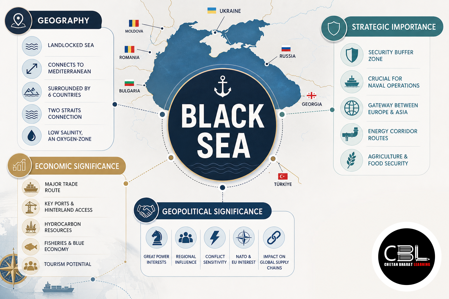
It is a large, nearly enclosed sea situated between Southeastern Europe and Western Asia and is generally regarded as a marginal sea of the Atlantic Ocean system. It covers an area of roughly 436,000 square kilometres. The Balkan Peninsula lies towards its west, the Caucasus region towards the east, the East European Plain towards the north and Anatolia towards the south. This position places the water body at an important geographical junction between Europe and Asia.
Six internationally recognised states have coastlines on it: Bulgaria, Romania, Ukraine, Russia, Georgia and Türkiye. The Crimean Peninsula projects prominently into the northern part of the sea. Several major rivers drain into the basin, including the Danube, Dniester, Dnieper, Southern Bug and Rioni. The substantial freshwater input from rivers contributes to surface-water salinity that is lower than that of the open ocean.
Why is Black Sea in News?
India recently issued a security warning concerning vessels operating in the region that are Indian-flagged or employ Indian seafarers. Maritime advisories become particularly important in areas affected by military tensions because merchant ships and crews can face risks arising from mines, attacks, navigation restrictions, port disruptions and rapidly changing security conditions. Protection of Indian seafarers is significant because Indian nationals form an important part of the international maritime workforce.
The region has acquired heightened strategic importance because of the Russia-Ukraine conflict and its effects on commercial navigation and commodity flows. Ports in the area have traditionally played a major role in moving agricultural commodities, energy products and other goods between Eastern Europe and international markets. Disruptions can therefore have consequences beyond the immediate region. India’s Directorate General of Shipping is the principal maritime administration concerned with Indian shipping and seafarer-related regulatory matters.
Key Features of Black Sea
Its most important geographical characteristic for Prelims is its indirect connection with the Mediterranean. From the southern part of the sea, vessels pass through the Bosporus into the Sea of Marmara and then through the Dardanelles into the Aegean Sea, which forms part of the Mediterranean system. This narrow maritime chain makes the Turkish Straits strategically important for both commercial and naval access.
- Bordering states: Bulgaria, Romania, Ukraine, Russia, Georgia and Türkiye surround the sea.
- Bosporus: Connects it with the Sea of Marmara.
- Dardanelles: Connects the Sea of Marmara with the Aegean Sea.
- Kerch Strait: Links the main basin with the smaller Sea of Azov to the northeast.
- Major rivers: The Danube, Dnieper, Dniester, Southern Bug and Rioni are among the rivers draining into it.
- Crimean Peninsula: Projects into the northern part of the sea and has major strategic significance.
- Salinity: Its surface waters are less saline than typical open-ocean water because of substantial river inflow and restricted exchange with the Mediterranean.
- Deep waters: Much of its deeper water is oxygen-poor and rich in hydrogen sulphide, sharply limiting most higher forms of marine life at depth.
The unusual vertical structure of the sea is scientifically important. Fresher surface waters and denser, saltier deeper waters do not mix easily. Consequently, deep layers remain largely anoxic. For UPSC, this makes the region relevant not only to political geography but also to questions concerning enclosed seas, salinity, stratification and marine ecosystems.
Challenges Related to Regional Maritime Security
The principal contemporary challenge is the interaction between armed conflict and commercial navigation. Merchant vessels require predictable sea lanes, safe ports and reliable insurance arrangements. Military operations can introduce floating mines, restricted zones and risks to civilian ships. Even when ports remain physically operational, higher insurance costs or crew-safety concerns can disrupt commercial shipping.
The Turkish Straits create an additional strategic dimension because they form the only natural maritime passage connecting this enclosed basin with the Mediterranean. Navigation through the Bosporus and Dardanelles is governed in important respects by the Montreux Convention of 1936, which establishes rules concerning passage and gives Türkiye a significant role regarding warships, particularly during wartime. Geography therefore directly shapes the strategic balance of the region.
Environmental problems are equally important. Large rivers drain densely populated and agricultural regions into the sea, carrying nutrients and pollutants. Eutrophication, invasive species, overfishing and coastal development have historically placed pressure on marine ecosystems. Effective environmental management requires cooperation among littoral states and countries located farther upstream in the river basins. Aspirants can revise related international mapping topics through our UPSC current affairs library.
Way Forward for Maritime Stability
Commercial shipping requires clearly communicated navigation warnings, updated risk assessments and effective coordination between maritime administrations, shipowners and crews. Vessels entering conflict-affected waters need contingency planning and continuous monitoring of official advisories. Protecting civilian seafarers should remain a priority irrespective of wider geopolitical disagreements.
Preserving safe channels for essential civilian trade can also reduce international economic spillovers. The region connects major agricultural and industrial production centres with overseas markets, so prolonged shipping disruption can affect commodity availability and transport costs elsewhere. International maritime law and established arrangements for the Turkish Straits remain important components of predictable navigation.
Long-term regional stability additionally requires environmental cooperation. Rivers and marine ecosystems do not follow political boundaries, making coordinated pollution control, fisheries management and ecosystem monitoring necessary. The International Maritime Organization provides the global framework for maritime safety, security and prevention of pollution from ships. For India, monitoring developments in this region is important for protecting seafarers, understanding global trade disruptions and assessing the wider consequences of Eurasian geopolitical change.
Prelims Practice Corner
-
Which of the following countries border the Black Sea?
1. Romania
2. Georgia
3. Bulgaria
4. MoldovaSelect the correct answer:
(a) 1 and 2 only (b) 1, 2 and 3 only (c) 2, 3 and 4 only (d) 1, 2, 3 and 4Answer: (b) 1, 2 and 3 only. Moldova does not possess a coastline on the sea.
-
The Bosporus Strait connects:
(a) Sea of Marmara and Black Sea
(b) Mediterranean Sea and Red Sea
(c) Aegean Sea and Adriatic Sea
(d) Sea of Azov and Black SeaAnswer: (a) Sea of Marmara and Black Sea.
-
The Kerch Strait connects the Sea of Azov with the:
(a) Baltic Sea
(b) Caspian Sea
(c) Black Sea
(d) Adriatic SeaAnswer: (c) Black Sea.
-
Which of the following rivers drain into the Black Sea basin?
1. Danube
2. Dnieper
3. Dniester
4. Southern BugSelect the correct answer:
(a) 1 and 2 only (b) 1, 2 and 3 only (c) 2 and 4 only (d) 1, 2, 3 and 4Answer: (d) 1, 2, 3 and 4.
-
Consider the following sequence from the Black Sea towards the Mediterranean:
(a) Dardanelles → Bosporus → Sea of Marmara
(b) Bosporus → Sea of Marmara → Dardanelles
(c) Kerch → Dardanelles → Bosporus
(d) Bosporus → Kerch → DardanellesAnswer: (b) Bosporus → Sea of Marmara → Dardanelles.
Mains Practice Questions
-
The strategic importance of an enclosed or semi-enclosed sea is often determined by the straits connecting it with the wider ocean. Explain with reference to the Black Sea region. (10 marks)
Outline: Enclosed geography → Bosporus → Sea of Marmara → Dardanelles → Mediterranean access → Turkish control → Montreux Convention → commercial shipping → naval significance → regional security.
-
Examine how instability in the Black Sea region can produce economic and maritime consequences beyond Eastern Europe. (15 marks)
Outline: Strategic location → Russia-Ukraine conflict → ports and shipping → grain and commodities → maritime insurance → seafarer security → Turkish Straits → global supply chains → need for safe navigation and diplomatic stability.
FAQs on Black Sea
- Which countries border the sea?
- The six littoral states are Bulgaria, Romania, Ukraine, Russia, Georgia and Türkiye.
- Which strait connects it with the Sea of Marmara?
- The Bosporus Strait provides the connection. The Sea of Marmara subsequently connects with the Aegean through the Dardanelles.
- Why is the region economically important?
- Its ports and waterways support international movement of agricultural commodities, energy products and other goods from Eastern Europe and the wider Eurasian region, while the Turkish Straits provide access towards the Mediterranean and global maritime routes.
Related Current Affairs
Preparing for UPSC, PCS or HCS?
Talk to a mentor at Chetan Bharat Learning, Chandigarh. Free guidance on choosing the right exam and building a study plan.
Chat on WhatsAppCall 97793 53345UPSC / IAS / PCS coaching in Chandigarh · Trusted by aspirants across Punjab & Haryana
Leave a Reply
You must be logged in to post a comment.