

UPSC Syllabus Mapping
| GS Paper | Subject |
|---|---|
| GS-I and GS-III | Indian Geography, Drainage Systems, Water Resources and Energy Infrastructure |
What is Mahanadi River?
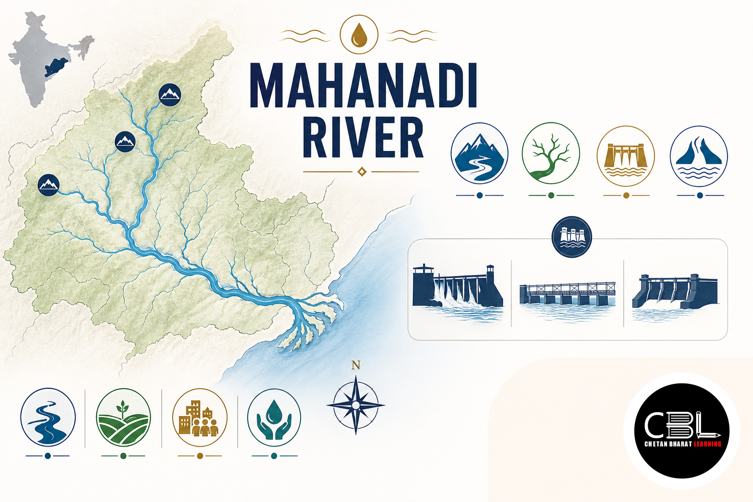
The river is one of the major east-flowing drainage systems of peninsular India. Its course lies principally within Chhattisgarh and Odisha, although its drainage basin extends into adjoining states. Like several major peninsular rivers, it ultimately drains into the Bay of Bengal. Consequently, it forms part of the broad eastward drainage pattern shaped by the general tilt of the Peninsular Plateau.
The river rises near the Sihawa Hills in the Dhamtari region of Chhattisgarh. Small streams in the surrounding uplands contribute to its initial flow. It first follows a generally northerly course before turning eastwards across the plains. Subsequently, several tributaries enlarge its discharge as it moves towards Odisha.
The river has a total length of roughly 850 kilometres. Its basin lies between several important physiographic regions, including uplands of central India and the Eastern Ghats. Moreover, the Maikal region influences the wider western drainage divide. These geographical boundaries help determine the basin’s catchment and tributary pattern.
The drainage basin primarily covers Chhattisgarh and Odisha. Smaller portions extend into Jharkhand, Maharashtra and Madhya Pradesh. Therefore, management of the river has an interstate dimension involving water allocation, dams, floods and basin planning. This makes the drainage system relevant to both physical geography and federal water governance.
After entering the Odisha plains, the river approaches the coastal lowlands and divides into a network of distributaries. These channels have helped build an extensive delta through repeated sediment deposition. Eventually, the drainage system reaches the Bay of Bengal along the Odisha coast. The river’s lower course therefore provides a classic example of delta-forming processes in eastern India.
Why is Mahanadi River in News?
The immediate context comes from offshore hydrocarbon exploration. State-owned Oil and Natural Gas Corporation has spudded a deepwater appraisal well in the offshore Mahanadi Basin. Spudding refers to the commencement of drilling operations for a well. An appraisal well generally helps companies assess the size, characteristics and commercial potential of a previously identified hydrocarbon accumulation.
The offshore basin is geologically connected with the long-term deposition of sediments transported towards India’s eastern continental margin. Over geological time, river-borne sediments accumulated within the basin and contributed to thick sedimentary sequences. Such sedimentary basins can contain conditions suitable for hydrocarbon generation and accumulation. Therefore, offshore exploration connects physical geography with India’s energy-security objectives.
The news also provides an opportunity to distinguish a river basin from an offshore sedimentary basin. The drainage basin describes the terrestrial area from which water flows into the river and its tributaries. In contrast, the offshore basin refers to geological sedimentary formations extending beneath the continental margin. Although related through sediment supply and geological history, the two concepts are not identical.
Deepwater exploration poses significant technological and financial challenges. Operators need specialised drilling platforms, subsea equipment and detailed geological information. Moreover, offshore operations require strong environmental safeguards because accidents can affect marine ecosystems and coastal livelihoods. Commercial discoveries therefore need evaluation alongside safety and ecological considerations.
Oil and Natural Gas Corporation is India’s state-owned exploration and production company involved in domestic and overseas hydrocarbon activities. For UPSC, the current development should trigger revision of east-flowing rivers, sedimentary basins and India’s offshore energy geography. The topic can consequently appear in geography as well as infrastructure and energy questions.
Key Features
The drainage system receives water from several important tributaries. Major tributaries include the Seonath, Hasdeo, Mand, Ib, Ong, Jonk and Tel systems. Many of these join the main channel before it enters the lower coastal plain. Consequently, their catchments significantly influence seasonal discharge, sediment movement and reservoir management.
Hirakud Dam near Sambalpur is the best-known multipurpose project on the main river. It created a large reservoir and serves functions such as flood moderation, irrigation and power generation. Furthermore, the wider basin contains several other reservoirs and water-control structures. Candidates should distinguish projects directly on the main river from those situated on tributaries within its basin.
Sediment deposition becomes particularly important in the lower course. As the river approaches flatter coastal terrain, its velocity and sediment-carrying capacity change. The channel then divides into distributaries and deposits material across the deltaic plain. Therefore, the lower basin supports fertile agriculture while also remaining vulnerable to floods and changing channel patterns.
The river system also contributes freshwater to the Chilika lagoon through distributary channels and associated drainage. Daya and Bhargavi are particularly relevant to this connection. Chilika is a brackish-water lagoon on the Odisha coast and a Ramsar wetland of international importance. Consequently, changes in freshwater and sediment flows can influence its ecological conditions.
The delta lies on a cyclone-prone coastline. Heavy monsoon rainfall, high river discharge and coastal storm conditions can combine to create complex flood risks. In addition, sedimentation can alter channel capacity over time. Integrated basin and coastal management therefore becomes essential for protecting settlements, agriculture and ecosystems.
Challenges
Flood management remains a persistent challenge in the lower basin. Intense monsoon rainfall can rapidly increase discharge, while sediment deposition can affect the capacity of river channels. Moreover, low-lying deltaic settlements face additional exposure to coastal hazards. Authorities therefore need reservoir operations, forecasts and local evacuation systems to work together.
Interstate water management creates another governance challenge. Upstream water storage and withdrawals can affect downstream availability and seasonal flow patterns. Chhattisgarh and Odisha have consequently had disagreements over water development in the basin. Cooperative data sharing and basin-level planning are essential because political boundaries do not coincide with hydrological boundaries.
Sedimentation creates both benefits and costs. Sediment supports delta formation and can replenish fertile floodplains. However, excessive deposition can reduce reservoir storage and alter river channels. Conversely, trapping too much sediment behind dams can affect downstream geomorphology and coastal sediment supply. Therefore, sediment management requires a basin-wide perspective.
Climate variability can intensify these difficulties. Changes in the timing and intensity of rainfall may produce longer dry periods alongside extreme precipitation events. Consequently, water managers must prepare for both scarcity and floods rather than treating them as unrelated problems. Reservoir operating rules may also need periodic reassessment under changing hydrological conditions.
Offshore energy development adds another environmental dimension. Hydrocarbon exploration can strengthen domestic energy availability, but drilling requires rigorous safety and marine-impact assessment. Coastal wetlands, fisheries and livelihoods need adequate safeguards. For related geography and environmental topics, aspirants can use our UPSC current affairs library.
Way Forward
Basin management should begin with transparent hydrological data. States need timely information on rainfall, reservoir storage, withdrawals and river discharge. Moreover, common datasets can improve both flood forecasting and interstate negotiations. Cooperative institutions work more effectively when all parties rely on compatible scientific information.
Authorities should integrate reservoir management with floodplain planning. Dams can moderate some flood peaks, but they cannot eliminate all downstream risk. Therefore, governments must protect natural drainage channels and discourage unsafe construction in highly vulnerable floodplains. Forecast-based reservoir operations can complement these land-use measures.
Environmental flows and sediment movement also require greater attention. Rivers perform ecological functions beyond supplying water for irrigation, industry and cities. Furthermore, downstream wetlands and deltaic ecosystems depend on freshwater and sediment regimes. Basin planning should consequently consider ecosystem needs when evaluating new storage or diversion projects.
Chilika and other coastal ecosystems require coordination between river-basin and coastal-zone authorities. Freshwater flows influence salinity, sedimentation and habitat conditions within the lagoon system. Similarly, coastal processes can affect river mouths and distributary channels. Integrated management can therefore reduce the institutional separation between inland water and coastal ecology.
Finally, offshore exploration should combine energy-security objectives with stringent environmental and safety standards. The Central Water Commission provides an important institutional reference for India’s water-resource assessment and river management. Mahanadi River demonstrates how drainage geography connects agriculture, dams, wetlands, interstate relations and offshore resources. Therefore, integrated basin management remains essential for balancing development with long-term ecological resilience.
Prelims Practice Corner
- 1. The Mahanadi originates in which State?
- (a) Odisha
- (b) Chhattisgarh
- (c) Jharkhand
- (d) Maharashtra
Answer: (b) The river rises near the Sihawa Hills in Chhattisgarh.
- 2. Which of the following is a major dam on the main Mahanadi?
- (a) Hirakud
- (b) Nagarjuna Sagar
- (c) Tehri
- (d) Idukki
Answer: (a) Hirakud Dam is located across the river near Sambalpur in Odisha.
- 3. Consider the following rivers: 1. Hasdeo 2. Ib 3. Seonath 4. Mand. How many of the above belong to the Mahanadi drainage system?
- (a) Only one
- (b) Only two
- (c) Only three
- (d) All four
Answer: (d) Hasdeo, Ib, Seonath and Mand are all part of the drainage system.
- 4. Consider the following statements about Chilika Lake: 1. It is located on the Odisha coast. 2. It receives freshwater from channels associated with the Mahanadi system. 3. It is a Ramsar wetland. Which statements are correct?
- (a) 1 only
- (b) 1 and 2 only
- (c) 2 and 3 only
- (d) 1, 2 and 3
Answer: (d) All three statements are correct.
- 5. In petroleum exploration, an appraisal well is primarily drilled to:
- (a) Divert river water
- (b) Assess a discovered hydrocarbon accumulation
- (c) Measure monsoon rainfall
- (d) Store crude oil permanently
Answer: (b) An appraisal well helps assess the extent and characteristics of a hydrocarbon discovery.
Mains Practice Questions
- 1. Examine the geographical and economic significance of the Mahanadi basin for eastern India. (10 marks)
Outline: Describe origin, course and delta; discuss irrigation, hydropower, agriculture, wetlands and settlements; add offshore sedimentary-basin relevance; conclude with integrated basin management.
- 2. River-basin management in India requires balancing upstream development, downstream ecology and climate resilience. Discuss with suitable examples. (15 marks)
Outline: Explain interstate river systems; discuss dams, water allocation, floods, sediment and environmental flows; examine delta and wetland impacts; recommend shared data, cooperative institutions and integrated planning.
FAQs on Mahanadi Basin
- Where does the river originate and where does it drain?
It originates near the Sihawa Hills in Chhattisgarh and follows an eastward course into Odisha before its distributary system reaches the Bay of Bengal.
- Which are its important tributaries?
Important tributaries include the Seonath, Hasdeo, Mand, Ib, Ong, Jonk and Tel systems. Together, they drain a large part of central-eastern India.
- How is the drainage system connected with Chilika Lake?
Distributaries and associated channels from the lower basin contribute freshwater to the Chilika lagoon. Daya and Bhargavi are particularly important in this hydrological connection.
Related Current Affairs
Preparing for UPSC, PCS or HCS?
Talk to a mentor at Chetan Bharat Learning, Chandigarh. Free guidance on choosing the right exam and building a study plan.
Chat on WhatsAppCall 97793 53345UPSC / IAS / PCS coaching in Chandigarh · Trusted by aspirants across Punjab & Haryana
Leave a Reply
You must be logged in to post a comment.