
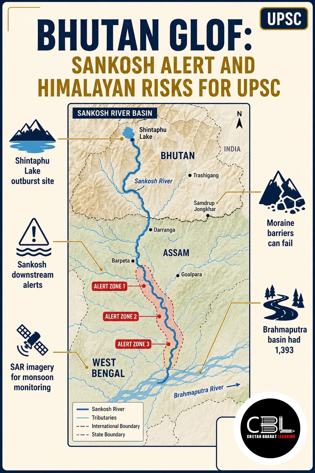
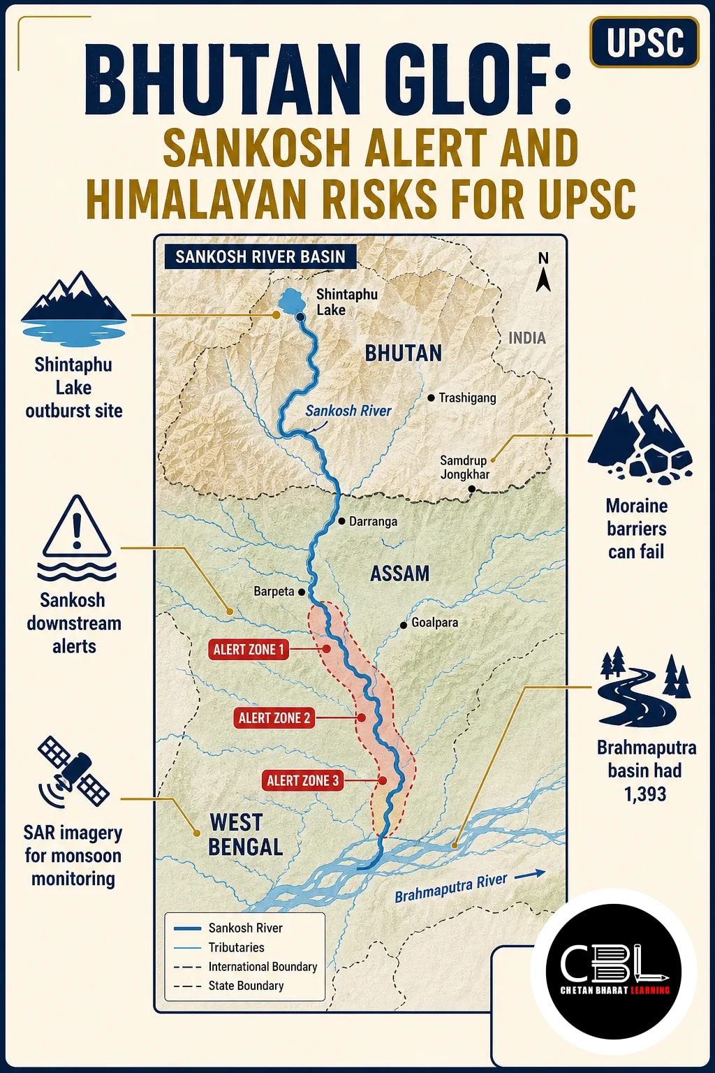
Bhutan GLOF alerts along the Sankosh now have an additional assessment: Kokrajhar authorities said the river was receding and they did not anticipate flooding in vulnerable areas. This follow-up examines the hazard behind the earlier Sankosh alert and its relevance to geography and environment.
Quick answer: The Bhutan GLOF was reported at Shintaphu Lake in Gasa district, prompting alerts in Assam and West Bengal over possible downstream effects along the Sankosh. In Kokrajhar, authorities subsequently observed receding water and did not expect inundation in vulnerable areas. The event highlights the need for cross-border warning and Himalayan lake monitoring.
Where did the Bhutan GLOF occur?
The reported outburst occurred at Shintaphu Lake in Bhutan’s Gasa district. It prompted downstream alerts because of possible effects along the Sankosh river in India.
| Location or feature | What to remember |
|---|---|
| Shintaphu Lake | Reported outburst site in Gasa district, Bhutan |
| Sankosh river | River monitored for possible downstream effects in India |
| Kokrajhar and Dhubri | Assam districts where authorities tracked potential impacts |
| West Bengal | Authorities also sounded alerts in the state |
In Kokrajhar, the district commissioner said Sankosh water was receding during his visit. Therefore, authorities did not anticipate inundation in vulnerable areas at that point. An alert, however, indicates preparedness for possible flooding; it does not establish that inundation occurred.
What causes a glacial lake outburst flood?
A glacial lake outburst flood (GLOF) occurs when water held by a glacier or moraine releases suddenly. Glacial lakes can form in front of, on top of, or beneath a glacier.
A moraine is an accumulation of material deposited by a glacier, including sand, gravel and boulders. Unlike solid bedrock, a moraine barrier contains loose material and can fail. A sudden inflow, overtopping or erosion can breach such a barrier and send water downstream.
These floods can carry very large volumes of water in a short time. In past events, recorded peak flows have reached 15,000 cubic metres per second; this is not a measured flow for the Shintaphu event. For comparison, the 2023 Sikkim GLOF killed 55 people.
Why are Himalayan glacial lakes a growing concern?
Glacier retreat can create or enlarge lakes, increasing the importance of assessing unstable natural barriers. As glaciers lose mass, water may collect in newly exposed depressions; some lakes are then held back by moraines.
The National Disaster Management Authority (NDMA) links widespread retreat in the Hindu Kush Himalaya to the formation of numerous glacial lakes. However, climate change alters the conditions in which hazards develop; it does not by itself establish the cause of an individual flood. Intense rainfall, sudden water inflow and unstable slopes can also contribute to a release.
The National Remote Sensing Centre (NRSC) inventoried glacial lakes and water bodies in Himalayan regions of Indian river basins during 2011–15. The Central Water Commission (CWC) sponsored the project. Its basin-wise counts provide a useful baseline, not a count of lakes independently classified as dangerous.
| River basin | Glacial lakes and water bodies inventoried |
|---|---|
| Indus | 352 |
| Ganga | 283 |
| Brahmaputra | 1,393 |
These figures cover the inventory period, rather than current lake numbers. For broader context, see the CBL analysis of Himalayan glacier retreat and water risks.
What are the downstream risks and governance challenges?
A sudden release can threaten people and infrastructure far below the lake. The Bhutan GLOF also illustrates why authorities must assess a hazard across administrative and national boundaries.
- Short response time: Rapid flows can leave downstream communities little time to act; therefore, warnings must reach people quickly.
- Changing hazards: Lake size alone cannot establish danger. The barrier, parent glacier and surrounding terrain also matter.
- Infrastructure exposure: Settlements, roads and other assets in river valleys face potential damage; consequently, planning must consider the full downstream path.
- Cross-border coordination: An upstream event can require downstream action in another country. Therefore, information exchange matters alongside district-level preparedness.
Not every Himalayan flood is a GLOF: landslide blockages and other circumstances can also cause sudden releases. For instance, a landslide blocked the Phuktal river in Ladakh on 31 December 2014, creating a potential flood situation on 7 May 2015. The Nepal flash floods analysis offers related regional context.
How can authorities reduce GLOF risk?
Risk reduction requires lake assessment, targeted intervention and warnings that lead to timely local action. NDMA guidelines place identification and mapping at the start of this process.
Monitor and prioritise lakes
Authorities can assess a lake using its condition, dam, parent glacier and surrounding topography. They can also combine field observations with records of past events and the physical characteristics of the site.
NDMA recommends Synthetic Aperture Radar (SAR) imagery to detect changes in water bodies during the monsoon. Moreover, it envisages year-round space monitoring as a complement and precursor to ground-based early warning at critical lakes. Satellite detection alone, however, cannot evacuate a community.
Link engineering with preparedness
Where appropriate, authorities can reduce lake volume through controlled breaching, outlet structures, pumping, siphoning or a tunnel. Each option needs site-specific assessment because the barrier and surrounding slopes differ.
Finally, monitoring should connect to cross-border information sharing, district alerts, evacuation routes and community drills. This approach addresses both the physical hazard and the exposure of people downstream. The Bhutan GLOF response shows why preparedness must continue even when a local assessment indicates receding water.
Source: Indian Express Explained, 30 October 2026
- Bhutan Glacial Flood: Sankosh Alert for UPSC (30 Oct 2026)
- Himalayan Glaciers: Tipping Point and Water Risks (21 Sep 2026)
- Nepal Flash Floods: Himalayan Tsunami, GLOF (1 Sep 2026)
Punjab PCS and Haryana HCS General Studies can test glacial landforms, Himalayan rivers and disaster management. In addition, candidates should connect early warning with district-level preparedness without assuming that the Sankosh alert applied to either state.
Prelims Practice Corner
Mains Practice Questions
Frequently Asked Questions
Where was the Bhutan GLOF reported?
It was reported at Shintaphu Lake in Bhutan’s Gasa district. Consequently, authorities issued alerts for possible downstream effects along the Sankosh.
Did Kokrajhar authorities expect a flood after inspecting the Sankosh?
No, they did not anticipate inundation in vulnerable areas at that point. The district commissioner said the river water was receding during his visit.
Does climate change cause every glacial lake outburst flood?
No, climate change alone does not establish the cause of an individual event. However, glacier retreat can change the physical conditions in which such hazards develop.
How can authorities monitor potentially dangerous glacial lakes?
Authorities can combine satellite imagery with field assessment and ground-based warning. For example, NDMA recommends Synthetic Aperture Radar imagery to detect changes during the monsoon.
Related Current Affairs
Preparing for UPSC, PCS or HCS?
Talk to a mentor at Chetan Bharat Learning, Chandigarh. Free guidance on choosing the right exam and building a study plan.
Chat on WhatsAppCall 97793 53345UPSC / IAS / PCS coaching in Chandigarh · Trusted by aspirants across Punjab & Haryana

 Ananya RanaIAS · AIR 60
 Aditya SharmaIAS · AIR 70
 Ria Kaur SethiIPS · AIR 89
 Aman AloonIRS · AIR 295
 Sumer Singh VirkIRS · AIR 335
 Shivani PanchalIAS

Leave a Reply
You must be logged in to post a comment.